Feature
●LOCATIONS: Our map features lighthouses, beaches, bike routes, bike shops, campgrounds, ferries, bike ferries, marinas and hiking trails around Martas Vinyard.
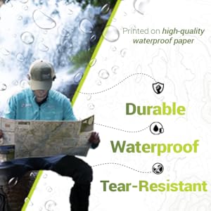
●DURABLE & WATERPROOF: Our Adirondack adventure map is printed on high-quality waterproof paper - making it durable, waterproof, and tear-resistant.
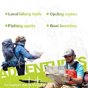
●MULTI-ACTIVITY: Hiking and fishing information, including river currents, labeled fishing pools, access points, parking areas, area fly shops, and more. Hiking information for nearby trails.
●PERFECT GIFT FOR TRAVELERS: Do you have a friend traveling to the Adirondacks? This will make the perfect gift.
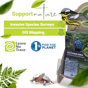
●SUPPORT NATURE: This map highlights river health and native species through a partnership with the Ausable River Association. We give 1% back to nonprofits through 1% for the Planet.
Description

Take a walk on the wild side!
Our maps feature hiking trails, boating information, cycling routes and much more. These maps measure 18x24" (unfolded), and 4x6" (folded).
|
|
|
|
|---|---|---|
Stay safe with our MapsMany places in the Adirondacks have limited cell service and even with service, batteries die faster than you expect. Having a durable and waterproof map in your pack is essential. Having one in your pack before you leave is a huge safety line ? it also serves as a good planning tool ? so you have a better idea of situations you may come across while out on the trail. |
An inspiring gift for any HikerOur maps are a perfect gift for someone who loves hiking or traveling. When was the last time that a gift you bought made someones eyes light up? We promise you: this is that gift! Expertly researched, lovingly illustrated, and printed on the best waterproof and durable paper. |
Multi-usageThese maps can be used to find local hiking trails, plan your cycling routes, or scope out the best fishing spots. Our lake maps have a lot of boating and fishing information, including lake depths, shoals, DEC boat launches, marinas, campsites, and more. Our outdoor adventure maps include hiking information for some of the most popular areas, including the Pharoah Lake Wilderness Area, High Peaks Wilderness, and Acadia National Park. Our maps cover everything so you can safely enjoy exploring. |


About the Brand
Our brand is inspired by nature, and our mission is to educate the public through high-quality maps. We started by making maps for environmental research and then discovered a need for beautiful maps ? waterproof and durable ones that people could use. That’s how Green Goat maps was born. We offer a variety of maps in various locations to meet everyones needs.
|
|
|
|
|---|---|---|
Supports NatureOur maps include information about responsible recreation through our membership with Leave No Trace and they promote environmental stewardship as a proud member of 1% for the Planet. |
High-QualityOur adventure maps are printed on high-quality waterproof paper - making them durable, waterproof, and tear-resistant ? so they are a perfect hiking companion even when it’s raining. These maps are durable in all conditions and can withstand years of use in hand and on the trail. |
Born from ResearchGreen Goat mappers are researchers at heart ? our partner company Adirondack Research does GIS mapping and environmental research all over the world. All we did was take our experience and love for the environment and make them into world-class maps. |


|

|

|

|
|
|---|---|---|---|---|
| Ausable River Fly Fishing Map | Saranac Lake Boating & Fishing Map | Adirondacks Old Forge Area Outdoor Adventure Map | Burlington Vermont Outdoor Adventure Map | |
| Customer Reviews | 1
| 6
| 1
| 2
|
| Price | $12.95 | $12.95 | $12.95 | $11.95 |
| About the Maps | Our Ausable River Fly Fishing Map shows river current, access paths, parking areas, NYS fishing regulations, a hatch chart, local fly shops, and more. | The Saranac Lake Boating and Fishing Map shows locks and boat launches, shoals and aquatic plant beds for fishing, marinas and other features important for paddlers and boaters. | The Old Forge Area Trail Map shows Adirondack trail networks, boat access sites, and points of interest between Old Forge and Blue Mountain Lake near the Adirondack High Peaks. | The Burlington, VT Outdoor Adventure Map features some of the most popular hikes, hiking trails, and cycling routes of northern Vermont and the Champlain Valley. |
| Map measures | Unfolded: 24×12” Folded: 4×6” | Unfolded: 18x24" Folded: 4x6" | Unfolded: 18x24" Folded: 4x6" | Unfolded: 18x24" Folded: 4x6" |
| Category | Fishing Charts & Maps | Fishing Charts & Maps | Topographic Maps | Camping & Hiking Topographic Maps |